


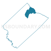
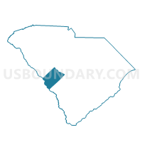
Oak Grove Voting District, Aiken County, South Carolina
About
Outline

Summary
| Unique Area Identifier | 664883 |
| Name | Oak Grove Voting District |
| County | Aiken County |
| State | South Carolina |
| Area (square miles) | 58.84 |
| Land Area (square miles) | 58.35 |
| Water Area (square miles) | 0.50 |
| % of Land Area | 99.15 |
| % of Water Area | 0.85 |
| Latitude of the Internal Point | 33.73882930 |
| Longtitude of the Internal Point | -81.52450940 |
Maps

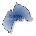
Graphs
Select a template below for downloading or customizing gragh for Oak Grove Voting District, Aiken County, South Carolina


Neighbors
Neighoring Voting District (by Name) Neighboring Voting District on the Map
- 002 Voting District, Lexington County, SC
- 008 Voting District, Lexington County, SC
- Monetta Voting District, Aiken County, SC
- New Holland Voting District, Aiken County, SC
- Shiloh Voting District, Aiken County, SC
- Ward Voting District, Aiken County, SC
Top 10 Neighboring County Subdivision (by Population) Neighboring County Subdivision on the Map
- Gilbert CCD, Lexington County, SC (20,028)
- Batesburg-Leesville CCD, Lexington County, SC (9,176)
- Aiken Northeast CCD, Aiken County, SC (5,817)
- Monetta CCD, Aiken County, SC (4,830)
- Wagener CCD, Aiken County, SC (4,815)
Top 10 Neighboring Unified School District (by Population) Neighboring Unified School District on the Map
- Aiken County School District, SC (162,758)
- Lexington School District 1, SC (121,030)
- Lexington School District 3, SC (13,248)
Top 10 Neighboring State Legislative District Lower Chamber (by Population) Neighboring State Legislative District Lower Chamber on the Map
- State House District 96, SC (41,272)
- State House District 86, SC (39,715)
- State House District 39, SC (34,678)
Top 10 Neighboring State Legislative District Upper Chamber (by Population) Neighboring State Legislative District Upper Chamber on the Map
- State Senate District 24, SC (99,070)
- State Senate District 25, SC (97,189)
- State Senate District 26, SC (91,335)
Top 10 Neighboring 111th Congressional District (by Population) Neighboring 111th Congressional District on the Map
Top 10 Neighboring Census Tract (by Population) Neighboring Census Tract on the Map
- Census Tract 202, Aiken County, SC (5,817)
- Census Tract 201, Aiken County, SC (4,830)
- Census Tract 217, Aiken County, SC (4,815)
- Census Tract 213.08, Lexington County, SC (4,227)
- Census Tract 214.03, Lexington County, SC (2,118)
Top 10 Neighboring 5-Digit ZIP Code Tabulation Area (by Population) Neighboring 5-Digit ZIP Code Tabulation Area on the Map
- 29070, SC (15,330)
- 29006, SC (9,565)
- 29805, SC (5,864)
- 29164, SC (4,690)
- 29129, SC (3,164)
- 29105, SC (1,514)